
We have all been faced with the challenge, a new body of water. Where do we start? During the winter months I love chasing Panfish. Hard water means searching for the largest Panfish I can find. Sure, I may spend some days in the spring chasing big Crappie or Bluegills but I prefer to target them under a canopy of hard water. Over the past few years I have been spending more and more time exploring new lakes for my next “best spot”. Long before I hit the ice I will spend lots of time planning my first recon mission to a new body of water.
In Southern Ontario many of the lakes I target for trophy Panfish are relatively small, often less than 100 acres. Sometimes these lakes seem more like puddles as they may only be 20 or 30 acres in size. The main fish I am targeting are Bluegill and Black Crappie. However, the occasional Pumpkinseed, White Crappie or Yellow Perch often drops by for a visit. They are always welcome of course. Many of the tactics I use for locating Panfish in small waters can be used in big waters also. These techniques are transferable across waterbodies. This system may prove useful wherever you are targeting Panfish through the ice.

Off-Ice Preparation
I will often research lakes before I visit them. I will not fish a lake before doing some research on its location, fish population and more. It is not in my nature to fish blind. I want to make the most of my time on the water. Now, I am not talking ‘dock talk’ or ‘web lurking’ trying to find some ‘secret info’ on a new lake. I have always taken an objective approach to my research. I always like to research any waterbody before I visit. I will seek out old stocking records, fisheries data, and more. If you live in Ontario try using the Fish ON-line web tool prepared by the Ontario Ministry of Natural Resources (link). This tool is designed to help anglers conduct research on fisheries in Ontario. Whether you are a weekend warrior or seasoned tournament pro, this website will provide you with some useful information on Ontario fisheries.

Develop a Plan
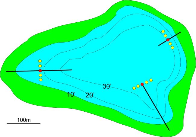
Once you have compiled some basic research it is time to put a plan together. How are you going break a lake down? Especially without the luxury of a boat to quickly scan areas for cover (e.g weeds) or structure (e.g. substrate, drop offs). Many ice anglers will utilize the idea of “ice trolling”. Covering a lot of water with a series of holes to find fish, and then zeroing in on high percentage areas once fish are located. I like to drill a series of holes across the lake feature I have selected. On small lakes I will aim to drill 10 or 12 holes approximately 30 feet apart in a single line. On larger waterbodies I will expand this spacing from 30ft to 50ft or even 100ft.
Primary Search Pattern
Once I have drill my initial line of holes I will begin searching each hole with my electronics. A good auger is important. My choice is the K-Drill auger with a Milwaukee drill. This auger is light and lets me move quickly. Once your primary search line is drilled you need to use your electronics. I use a Vexilar FL-20 Flasher with a dual frequency (9°/19°) transducer. This transducer is designed to cover a wide range of depths/situations. I prefer to use the 19° in shallow water situations (<15ft) and the 9° for deeper situations. Lure size and fish activity can play a role in my transducer choice. If water clarity is good I will also use a camera. I have been using the Aqua Vu Micro Plus for a few seasons and love it. This little camera is great for recon under the ice. The camera fits in your pocket and is ready to go at all times.

Secondary Search Pattern
Once fish are located note the depth and cover (e.g. weeds), substrate (sand, soft) and structure (flat, drop off). Then it is time to replicate this by working along the same piece of cover (weed type/weed edge), bottom type or structure (fat, drop off). I will expand on my Primary Search with holes extending along the productive area. I may reduce my spacing to help keep my baits in productive areas.
Added value from GPS units
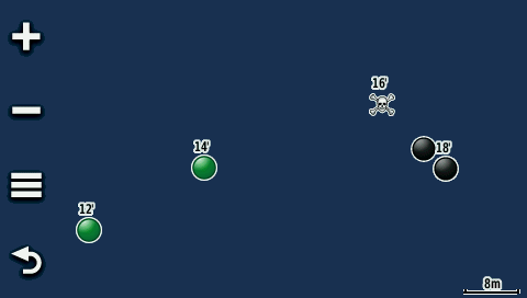
I use a GPS for all of my ice fishing. With or without bathymetric maps you a GPS can help any ice angler! During your primary and secondary searches a GPS unit can eliminate unproductive areas and be used to revisit productive areas. It is important to document all waypoints, regardless if you catch a fish or not. This is because data from unproductive locations may prove useful on another trip. Over the years I have used a variety of GPS Units but recently I have been using a Garmin Montana 680. This unit has a large, touch screen that is easy to navigate. Below is a screen shot of a typical ice fishing trip. I use various icons on my Garmin Montana GPS unit. In this screen shot weeds are marked with GREEN, no weeds are marked with BLACK and fish caught are marked with a SKULL. I also marked the depths at all waypoints (eg. 16′). This only takes a few seconds per waypoint with my GPS unit.
Article Summary
- There are lots of resources that can help anglers reduce the learning curve. Check the internet for resources, especially websites for your local Natural Resources or Fish & Game Department.
- Use your new knowledge to create a game plan and stick with it.
- Cover ice quickly with good augers, electronics (flashers, cameras) and GPS. Covering water not only finds fish but also eliminates unproductive areas.
Equipment Notes
- Rods: Fenwick Elite-Tech Ice Rods
- Reels: Pfueger President (Model 6920X)
- Line: Berkley Micro Ice, Berkley Nanofil, Berkley 100% Flourocarbon Leader
- Berkley Powerbait – Atomic Wishbone and Atomic Fry
- Berkley GULP Alive – Maggots
- Fiskas Tungsten
- Johnson Rattlin’ Scout Spoons
- Sebile Vibrato
- Flasher: Vexilar FL-20 Pro Pack
- Underwater Camera: Aqua Vu Mini Plus
- GPS Unit: Garmin Montana 680
- Mapping: Backroads Maps, Garmin LakeVu HD


Great article my friend! I’ll have to put this to the test!
LikeLiked by 1 person